France’s Diplomatic Maps Get a Reality Check: Mercator Era Ends in Paris
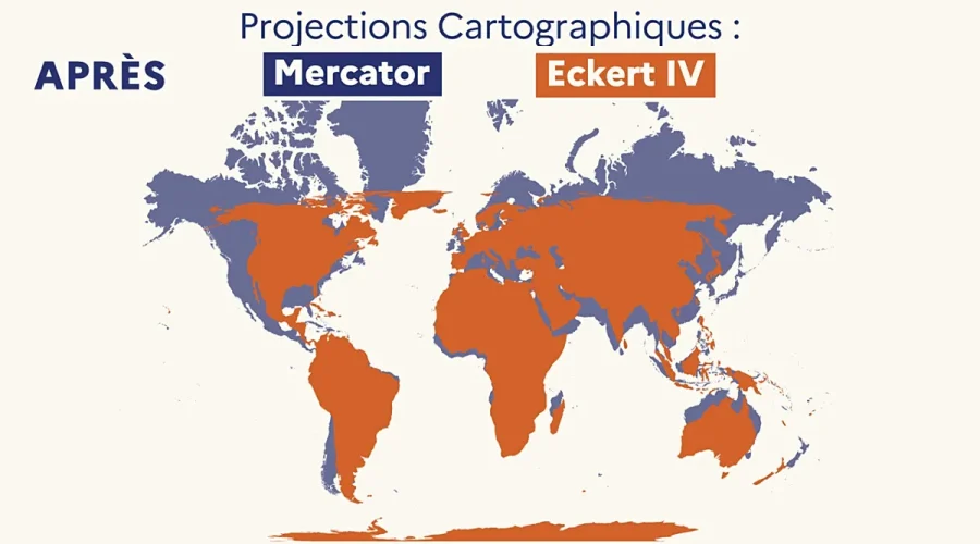
Usagevpn.com – For centuries, the world map that shaped European navigation, colonial ambition, and classroom geography has quietly inflated the visual weight of northern latitudes while compressing the equatorial belt. That era is now officially over in French foreign policy. On Friday, Foreign Minister Jean-Noël Barrot declared that his ministry will retire the Mercator projection from all official diplomatic cartography and replace it with the Eckert IV projection, a method first developed in 1906 that renders continental surface areas far more faithfully.
The shift means that France itself will appear noticeably smaller on the maps its diplomats carry into negotiations, while nations straddling the equator — from the United States to Russia to the countries of sub-Saharan Africa — will occupy their true proportional space. The change is symbolic in the sense that no border moves and no territory is gained or lost, yet Barrot framed it as a correction of long-standing perceptual bias embedded in Western cartographic tradition.
“The Time Has Come” to Correct a 16th-Century Inheritance
Speaking at the Sorbonne during a public gathering titled “La Fabrique de la diplomatie,” Barrot argued that the visual grammar of maps inherited from 16th-century Western navigators has shaped geopolitical imagination for generations. He made the case that the moment to revise that grammar had arrived.
“A map is never entirely neutral. Take the Mercator projection, the one every one of us has known since childhood. The areas we see on it do not correspond to actual areas: (…) The United States, Russia, China take on a disproportionate visual importance compared with Africa, Latin America or South-East Asia.”
To drive the point home, the minister invoked Greenland. On a Mercator chart the island sprawls across the upper right corner, appearing nearly as vast as the entire African continent. In reality, Greenland is roughly the same size as the Democratic Republic of Congo or Algeria — a fact that the old projection obscures by a factor of several.
“Changing the map obviously does not change the world. But correcting a representation that distorts it is already an act of truth,” Barrot stressed.
New York Redraws the Globe Hours Later
The Paris announcement landed within hours of a parallel development at the United Nations General Assembly, where delegates formally voted to abandon the Mercator projection in favour of the Equal Earth model, a projection devised in 2018 that preserves true surface-area ratios across all latitudes. The non-binding resolution, titled “Correcting the map” and sponsored by Togo, drew the support of 164 member states.
The African Union had already endorsed the Equal Earth projection in March of this year, and the UN text now urges individual member states to follow suit. Only the United States cast a vote against, with Washington denouncing the measure as a “radical ideological project.” The American objection centred on a passage in the resolution declaring that “correcting cartographic distortions relating to the size of continents constitutes an act of cognitive justice and memorial reparation.” Six nations — Estonia, Georgia, Lithuania, Moldova, Serbia, and Ukraine — abstained.
What the Resolution Does — and Does Not — Do
The UN was careful to clarify that the resolution neither bans the Mercator projection nor imposes a single mandatory map on any country. Its operative language “encourages governments, educational institutions, international organisations and technology companies to make use of the Equal Earth projection, or of other so-called ‘equal-area’ maps that preserve the true proportions of surface areas.” In other words, the instrument is hortatory, not coercive, and leaves room for national discretion in choosing among several mathematically valid equal-area alternatives.
France has joined the broader movement but has charted its own course within it. Rather than adopting the Equal Earth model recommended by the UN, Paris selected the Eckert IV projection. The two are closely related in their area-preserving mathematics, yet they differ in the precise shapes they assign to coastlines and landmasses. Both, however, eliminate the exponential inflation of polar regions that defines the Mercator distortion.
Classrooms, Screens, and the Slow Fade of Mercator
The practical reach of the new directive, at least for now, is confined to official diplomatic documents. In French schools, the overwhelming majority of world maps remain in Mercator format. Grégory, a senior history and geography teacher in Rennes, noted that while some textbooks do feature the Eckert or Peters projections — the latter being another equal-area method that renders continental surface areas with particular fidelity — their presence is “very rare.” Whether the foreign ministry’s decision will cascade into curriculum materials remains an open question.
Digital platforms tell a similar story. Google Maps and other mainstream navigation services continue to rely on a variant of the Mercator projection, meaning that the average user scrolling through a world view on a smartphone will still encounter the familiar visual hierarchy for the foreseeable future. The UN itself acknowledged that Mercator mapping will not vanish overnight.
Why the Distortion Matters Beyond Aesthetics
The Mercator projection was engineered in 1569 by Flemish cartographer Gerardus Mercator primarily for marine navigation: it preserves angles, making rhumb lines appear as straight segments, which was invaluable for sailors plotting courses. The price of that angular fidelity is a dramatic area distortion that grows with latitude. At 60° north, features are roughly twice their true size; near the poles, the inflation becomes unbounded. The result is a map that, for five centuries, has trained Western eyes to read the Arctic as vast and the tropics as compressed.
Equal-area projections such as Eckert IV, Peters, and Equal Earth sacrifice angular fidelity to guarantee that every square centimetre on the printed page represents the same number of square kilometres on the globe. The trade-off is deliberate: a diplomat or policymaker consulting a world map does not need to plot a sailing course, but does need an undistorted sense of relative scale. France’s decision to switch, timed alongside the UN vote, signals that at least two of the world’s most prominent diplomatic actors now consider the old visual hierarchy a legacy worth retiring.
Related Reading
Frequently Asked Questions
What is Paris drops Mercator projection?
Paris drops Mercator projection is the main topic of this guide. The article explains the context, practical details, and next steps readers should understand.
Why does Paris drops Mercator projection matter?
Paris drops Mercator projection matters because readers are looking for a useful answer, not just a short summary. Good content should match search intent and help them decide what to do next.