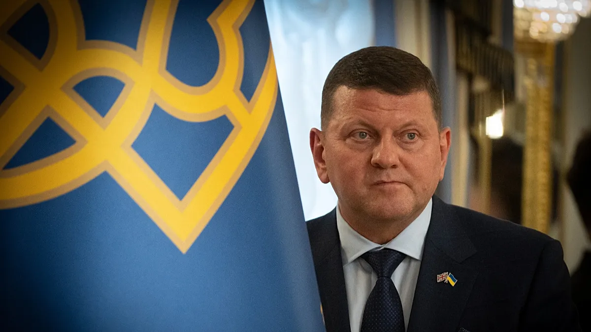
Ukraine’s Former Commander-in-Chief to Run for President, Reports Say
Ukraine s former commander in chief – Recent reports indicate that Valerii Zaluzhnyi, the former top military leader of Ukraine and current UK ambassador, is considering a presidential bid. This development has sparked discussions about the potential shift in Ukraine’s political landscape as the nation prepares for its next electoral cycle. According to Ukrainska Pravda, Zaluzhnyi was invited to Kyiv in mid-June, where President Volodymyr Zelenskyy reportedly sought his opinion on participating in the upcoming presidential elections, which are scheduled for the autumn.
Trust in Leadership Remains High
The Kyiv International Institute of Sociology (KIIS) recently released data revealing that public confidence in Zelenskyy has remained steady at 61% since early June. While this figure shows no significant decline compared to an April poll, it highlights the enduring support for the incumbent leader. However, the survey also included questions about trust in other political and military figures, offering a broader perspective on Ukrainian sentiment.
Among politicians, the mayor of Kharkiv, Ihor Terekhov, topped the trust rankings with 52%, though this still lags behind Zelenskyy’s approval. In contrast, military figures demonstrated higher levels of public confidence. Commander of Ukraine’s Unmanned Systems Forces, Robert “Magyar” Brovdi, earned a 70% trust rating, a testament to his strategic role in targeting Russian territory. This included successful operations such as mid-range strikes and drone attacks on Moscow and Crimea, regions considered heavily fortified by Moscow. Similarly, Kyrylo Budanov, head of Zelenskyy’s office, was also rated 70% by respondents, a result bolstered by his tenure as head of the Main Directorate of Intelligence (HUR).
A National Hero Turned Diplomat
Zaluzhnyi’s rise to prominence began in July 2021 when he was appointed commander-in-chief of Ukraine’s armed forces. This decision, reportedly made personally by Zelenskyy, surprised many due to Zaluzhnyi’s relatively low profile in public life. However, his leadership quickly became central to Ukraine’s war efforts after Russia launched its full-scale invasion in February 2022. Zaluzhnyi’s successful defense of Kyiv and the surrounding areas transformed him into a national symbol of resilience, even as he remained largely out of sight during the early stages of the conflict.
His reputation grew further during the 2022 counteroffensive when Ukrainian troops transitioned from defensive to offensive operations, reclaiming the Kharkiv region with remarkable speed. This campaign cemented his image as a figure of courage and strategic acumen, with stories of his leadership becoming part of Ukrainian folklore. Yet, by February 2024, Zelenskyy decided to replace Zaluzhnyi, citing the need to “renew the leadership” of the military following a major setback in the 2023 counteroffensive. The move was met with mixed reactions, with some speculating that Zelenskyy saw Zaluzhnyi’s rising popularity as a potential challenge to his own authority.
Public Sentiment and Political Aspirations
Despite his removal from the military, Zaluzhnyi’s public standing has not wavered. Recent polls show that he retains a 73% trust rating, positioning him as a formidable contender in the upcoming elections. This level of support contrasts sharply with his former colleagues, such as Brovdi and Budanov, who have not publicly expressed interest in running for office. While Brovdi’s focus remains on military operations, Budanov, who has been a key advisor to Zelenskyy, continues to serve in his administrative role.
“The inability of state institutions in Ukraine to improve the manpower levels of our armed forces without the use of unpopular measures” — a statement Zaluzhnyi made in an opinion piece following his removal, reflecting his frustration with the challenges facing the military.
Zaluzhnyi’s transition to diplomacy has been smooth, with his appointment as UK ambassador in 2024 emphasizing his role as a bridge between Ukraine and its international allies. In announcing the move, Zelenskyy claimed that Zaluzhnyi had expressed a preference for diplomacy, though the exact nature of this discussion remains unclear. Since then, Zaluzhnyi has maintained his status as a revered figure, with his actions and decisions continuing to resonate deeply with the Ukrainian public.
Legacy and Future Prospects
Zaluzhnyi’s legacy as a military leader is inextricably linked to Ukraine’s survival during its most critical moments. His ability to lead from the shadows, orchestrating operations that protected the nation’s capital and launched daring offensives, has left a lasting impression. However, the 2023 counteroffensive’s failure has raised questions about the effectiveness of current strategies and the role of leadership in shaping Ukraine’s military outcomes.
With his trust rating surpassing that of both Zelenskyy and other prominent figures, Zaluzhnyi’s potential return to politics could signal a significant shift in Ukraine’s power dynamics. If he decides to campaign, his appeal to voters seeking strong, decisive leadership may challenge Zelenskyy’s dominance. Yet, the decision to run will depend on whether Zaluzhnyi can translate his military achievements into a political platform that resonates with a broader electorate.
Analysts suggest that Zaluzhnyi’s candidacy could reflect a growing desire among Ukrainians for a leader who embodies both strength and strategy. His experience in command, coupled with his symbolic role in the nation’s defense, positions him as a unique candidate in a country where the war effort remains central to political discourse. While the details of his plans are still emerging, his high public approval suggests that the potential for a presidential run is not just a rumor but a plausible scenario.
Public Perception and Political Climate
Zaluzhnyi’s journey from battlefield commander to diplomat has been marked by a blend of admiration and speculation. His decision to step back from active military roles in 2024 was framed as a strategic move to focus on diplomacy, yet it also allowed him to remain in the public eye, maintaining his almost mythical status. This duality—being both a pragmatic leader and a symbol of national unity—has shaped his current appeal.
As the presidential elections approach, the competition is expected to be fierce. Zelenskyy’s support remains strong, but Zaluzhnyi’s growing influence could disrupt the status quo. His campaign, if launched, may emphasize stability, national pride, and a vision for Ukraine’s future. The military’s role in shaping public opinion cannot be overstated, and Zaluzhnyi’s trust ratings highlight how his leadership has become a touchstone for Ukrainian voters.
Whether Zaluzhnyi will officially announce his candidacy remains to be seen, but the momentum of his popularity suggests that his entry into politics is likely. This development underscores the evolving nature of Ukraine’s leadership, where military expertise and political ambition are increasingly intertwined. As the nation navigates the complexities of war and governance, Zaluzhnyi’s potential run could redefine the balance of power between the executive and military branches, offering a new chapter in Ukraine’s democratic journey.